|
HISTORY
Because of similarity of homes,
close proximity to each other, and connected history, the Colonial
and Bellaire neighborhoods, located four miles southwest of the
Central Business District, are grouped together.
The Colonial Hills addition is
set around Country Club Circle, and is part of the 1856 Anthony
B. Connor Survey. Between 1856 and the mid-1930's, much of this
land was used as a dairy farm. In 1936, J. M. Leonard, one of
the well-known Leonard brothers of Fort Worth, took much of the
land he had acquired in the area, and built the Colonial Country
Club. Some of the land east of the country club had been platted
in 1929.
South of Colonial Hills, and
west of Texas Christian University, is the Bellaire neighborhood.
Originally part of the 1870 H. H. Edwards Survey, most of the
land was divided into lots in 1926 and developed by Bellaire
Estates. Some of the owners of this land at the time included
Marvin and O. P. Leonard, as well as U. M. Simon, for which the
street Simondale is named.
As part of the 1868 Wade Hudson
Survey, the land along Bellaire Drive North was owned by Fred
Hammond in 1926. This land was inherited by Hammond from Edwin
T. Phillips, and was originally platted into small lots in 1926,
but was replatted in 1929 to become the T.C.U. football stadium.
In 1923, the City of Fort Worth
developed the Worth Hills Golf Course in this area. In 1962,
needing more campus space, T.C.U.'s President, Dr. M. E. Sadler,
made a trade with the city. He agreed to pay a large sum for
the golf course so that the city could buy land near Benbrook
Lake for a municipal course, if the city would pay an equal sum
to make a boulevard around the new campus. This boulevard is
now part of Stadium Drive and Bellaire Drive South.
Both the Colonial and Bellaire
neighborhoods were surveyed for platting by Brookes Baker, a
surveyor in Fort Worth since 1880.
|
|
NEIGHBORHOOD DESCRIPTION
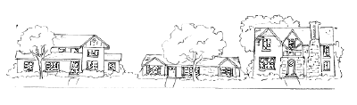
Large two-story Colonial, Spanish
and Tudor style homes dominate the Colonial and Bellaire neighborhoods.
These styles mix with ranch-style homes along Simondale and Alton
Road. At the southern end of these neighborhoods, these designs
are set among prairie cottage style homes. Many of the homes
in this area are made of stucco or brick, and many also have
tile roofs and basements.
The streets are curving, following
the contours of the land. On Simondale, bluff lots overlook a
spectacular view of the river valley and Fort Worth's west side.
Much of Colonial Parkway lots have views of the club golf course.
|
|
SCHOOLS
Elementary
Tanglewood, 3060 Overton Park W., 817-922-6815
Middle
W. P. McLean, 3816 Stadium Dr., 817-922-6830
High School
R. L. Paschal, 3001 Forest Park Blvd., 817-922-6600
|
|
OTHER INFORMATION
Nearest Fire Station: 3501 South Hills Ave., 817-871-6800, emergencies 911
Nearest Medical Facilities: Baylor All Saints Medical Center, 1400 Eighth Ave., 817-927-6102
Nearest Post Office: Trinity River Station, 4450 Oak Park Lane, 817-926-3497
Nearest Grocery Shopping: Westcliff Center
Nearest Mall: Hulen Mall
Nearest Park: Forest Park
City Council District Number: 9
School District Number: 5
Voting Precinct Number: 4095 (Colonial area), 1081 ( Bellaire
area)
|